
Topography of South America
Test your knowledge
South America presents one of the most striking examples of how topography governs environmental diversity and ecological function. The continent is defined by a strong west–east contrast: the Andes Mountains form a continuous high-elevation barrier along the western margin, while vast lowlands dominate the central and eastern regions. This sharp elevation gradient shapes atmospheric circulation, hydrology, and biogeography at the continental scale.
The Andes play a central role in modulating climate. Moist air masses from the Atlantic are forced to rise along the eastern slopes, producing heavy rainfall that sustains the Amazon Basin—the largest tropical rainforest and river system in the world. In contrast, descending dry air on the western side contributes to extreme aridity, exemplified by the Atacama Desert, one of the driest regions globally. This orographic effect creates pronounced ecological contrasts over relatively short distances.
The Amazon Basin itself represents a lowland megasystem characterized by dense river networks, seasonal flooding, and unparalleled biodiversity. Its hydrological connectivity supports nutrient cycling, carbon storage, and climate regulation at both regional and global scales. Moving southward, the landscape transitions into the fertile Pampas, where relatively flat terrain and moderate climate have supported intensive agriculture. Further south, Patagonia introduces a different regime—cooler temperatures, strong winds, and rugged terrain—reflecting both latitudinal position and topographic influence.
Major river systems, including the Amazon, Orinoco, and La Plata, integrate these diverse landscapes, linking highland and lowland processes. They function not only as hydrological corridors but also as drivers of ecological productivity and human settlement patterns.
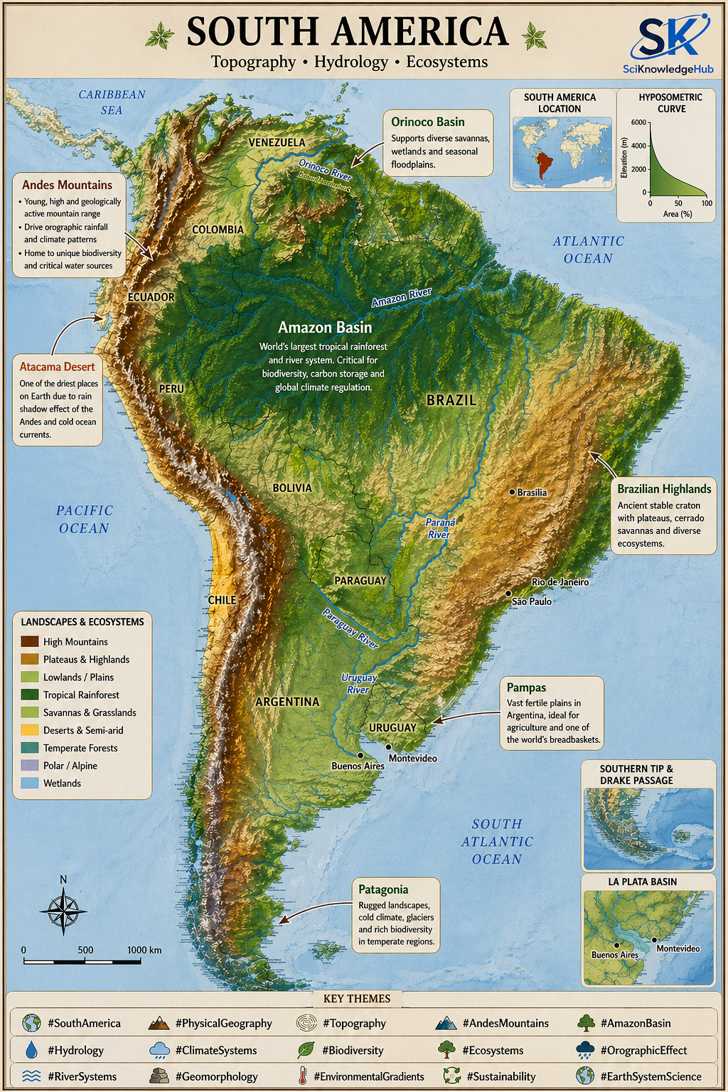
South America illustrates how relief, climate, and hydrology are tightly interconnected, producing a mosaic of ecosystems that range from hyper-arid deserts to humid rainforests and temperate grasslands. This interplay underpins the continent’s environmental complexity and its global significance in biodiversity and climate regulation.
River networks: The Amazon, Orinoco, and La Plata systems are clearly articulated, reinforcing the central role of hydrology in structuring ecosystems, agriculture, and human settlement. Overall, the figure serves as a concise visual synthesis of the continent’s geomorphology and its tight coupling with climate, biodiversity, and land use.
South America presents one of the most striking examples of how topography governs environmental diversity and ecological function. The continent is defined by a strong west–east contrast: the Andes Mountains form a continuous high-elevation barrier along the western margin, while vast lowlands dominate the central and eastern regions. This sharp elevation gradient shapes atmospheric circulation, hydrology, and biogeography at the continental scale.
#SouthAmerica #PhysicalGeography #Topography #AndesMountains #AmazonBasin #Biogeography #ClimateSystems #Hydrology #Geomorphology #EnvironmentalGradients #Ecosystems #Biodiversity #OrographicEffect #RiverSystems #Pampas #Patagonia #EarthSystemScience #LandscapeEcology
South America geography, Physical geography South America, South America ecosystems, Amazon Basin, Andes Mountains, South America rivers, South America biodiversity
Test your knowledge
What role does the Amazon Basin play in global carbon cycling and climate regulation?
The Amazon Basin functions as one of Earth’s largest biogeochemical engines, tightly coupling carbon storage with atmospheric processes. Its role is multidimensional